World Glaciers Explorer#
The world glacier explorer is an interactive web application with which you can learn (and teach) about the world’s glaciers, their location, their climate, and the ice they store. By “glaciers”, we mean all glaciers outside of the two continental ice sheets (Greenland and Antarctica).
You can start the app by clicking on this link: ![]()
Alternatively, you can start the app on mybinder (slightly slower in general, but a good alternative if our server is saturated). If you want to run the app on your own computer, see Launching from Docker below.
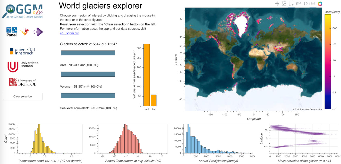
The app contains five elements:
the world map (upper right) displays thg glaciers’ location, with the color shading indicating the total glacier area in each pixel. Moving the mouse over a glacier pixel displays its exact glaciated area. When selecting a box on the map, the other elements in the app will update accordingly. Above the map, there is a toolbar: with the “Box Zoom” button, you can also zoom into a specific region. Click on “Reset” to set the map back to defaults (see the video below for a demo). Be aware that the map projection is slightly misleading: high latitudes appear much bigger on the map than they really are.
the clear selection button on the left resets the current glacier selection.
the bar plots (left of the map) indicate various statistics about the current glacier selection (default selection: all glaciers). The upper blue bar indicates the number of glaciers selected, the middle blue bar their total area, and the lower blue bar their estimated volume. This volume can be converted to its sea-level rise equivalent (in mm), which is the global sea-level rise to be expected if all glacier vanished. Only glaciers above sea-level are contributing to this figure, therefore there are two vertical orange bars: asl (above sea-level) and bsl (below sea-level). See the demo and explanations below on how to use this information.
the three climate histograms plots (lower row) display the distribution of the selected glaciers’ climate conditions. The y-axis is given in number of glaciers per bin, and the x-axis in the unit of the target variable (temperature trend, average temperature, average precipitation at the glacier location). Selecting a range of values in these plots also actualizes the map and the rest of the plots (see demo below).
the glacier elevation/altitude scatter plot (lower right) displays the average elevation of the glaciers on the map as a function of latitude (y-axis).
Video tutorials#
Part 1: app functionalities#
OGGM-Edu app: World Glaciers Explorer tutorial (part 1) on Vimeo
Part 2: example questions#
OGGM-Edu app: World Glaciers Explorer tutorial (part 2) on Vimeo
Questions to explore with this app#
We suggest motivating the app with a question to be answered in class. For example:
How many glaciers are there on Earth? How much volume do they represent?
How much would the sea-level rise if all glaciers melted? All glaciers in the Alps? In the Himalayas? etc.
What is the relationship between latitude and glacier elevation? Why?
Where are the locations with highest precipitation? And the driests?
Is there a relationship between average temperature and average precipitation?
How much glacier area is found on Greenland? In the European Alps? How does these number compare to, say, the area of Berlin, France, Mexico?
Does the number of glaciers in a region always correlate with their total volume?
What regions are most likely to contribute to sea-level rise? Where do we find glaciers with ice below sea-level?
Where are the glaciers which are warming the fastest? Why?
Where are the wettest glaciers in the Himalayas? (select all Himalayan glaciers first, then the wettest). Can you explain why?
Repeat the excercise above with other regions: Greenland, the Alps, etc.
And many more!
Resources#
Several pages from Glaciers and Climate on antarcticglaciers.org are highly relevant here
Warming trends at glaciers locations, a blog post by Fabien Maussion
Glacial Census Reveals Ice Thicknesses Around the World, EOS
OGGM-Edu Glaciology Lab 2 - Exploring glacier data provides a lesson plan and materials to use the World Glacier Explorer in a 1.5-2 hour class or lab session
Data sources#
Glacier location, elevation and area are obtained from the Randolph Glacier Inventory version 6. The climate data (temperature, precipitation, trends) is extracted from ERA5 data provided by the ECMWF. The glacier volume was provided by Farinotti et al., (2019)
Source code#
Code and data are on GitHub, MIT licensed.
Launching from Docker#
This application should work quite well online, either on our server or on mybinder. But you can also start the app locally, which will make it faster and less dependent on an internet connection (although you still need one to download the app, display the logos and the map).
To start the app locally, all you’ll need is to have Docker installed on your computer. From there, run this command into a terminal:
docker run -e BOKEH_ALLOW_WS_ORIGIN=127.0.0.1 -p 8083:8080 ghcr.io/oggm/bokeh:20220520 git+https://github.com/OGGM/world-glacier-explorer.git@stable app.ipynb
Once running, you should be able to start the app in your browser at this address: http://127.0.0.1:8083/.